Neila Creek, New South Wales
Project
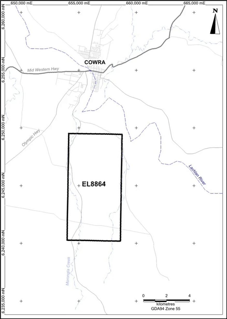
The Neila Creek tenement (EL8864) is an early-stage exploration prospect. However, its location in a recognised volcanic belt hosting large scale, world class mineralised systems offers a special opportunity. Three main historic prospects are located on the tenement and are of a structurally controlled copper – gold nature.
The presence of historic copper and or gold showings on the tenement with isolated recent rock samples containing high grade gold and copper, is evidence that there is a mineral system present. Such showings can always be narrow structurally controlled veins, but they can also represent ‘leakage’ from deeper, larger copper – gold systems. Such large systems may also occur beyond the depth of penetration of most geophysical methods. The majority of the tenement is covered by recent Cainozoic gravel and sand. These younger units would have limited the accuracy of conventional geochemistry and may also have affected interpretation and results reported by previous explorers.
Numerous exploration companies have conducted work on or adjacent to the Neila Creek tenement over a 50+ year period dating back to 1970. A considerable database of geochemical, geophysical and drilling data exists which has previously been subjected to comprehensive open-file review and assessment. GGR have brought to the prospect a considerable advantage by engaging technical personnel with first-hand experience in the exploration for porphyry style intrusive related copper – gold mineralisation associated with Ordovician volcanic/volcanoclastic rocks.
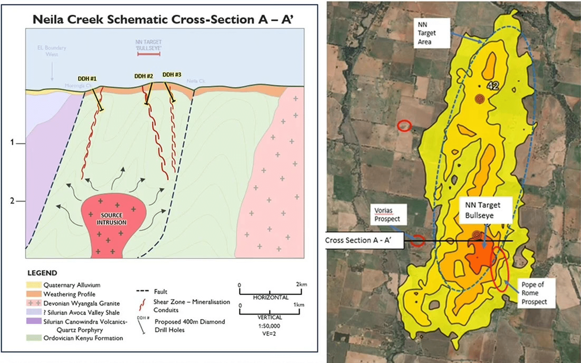
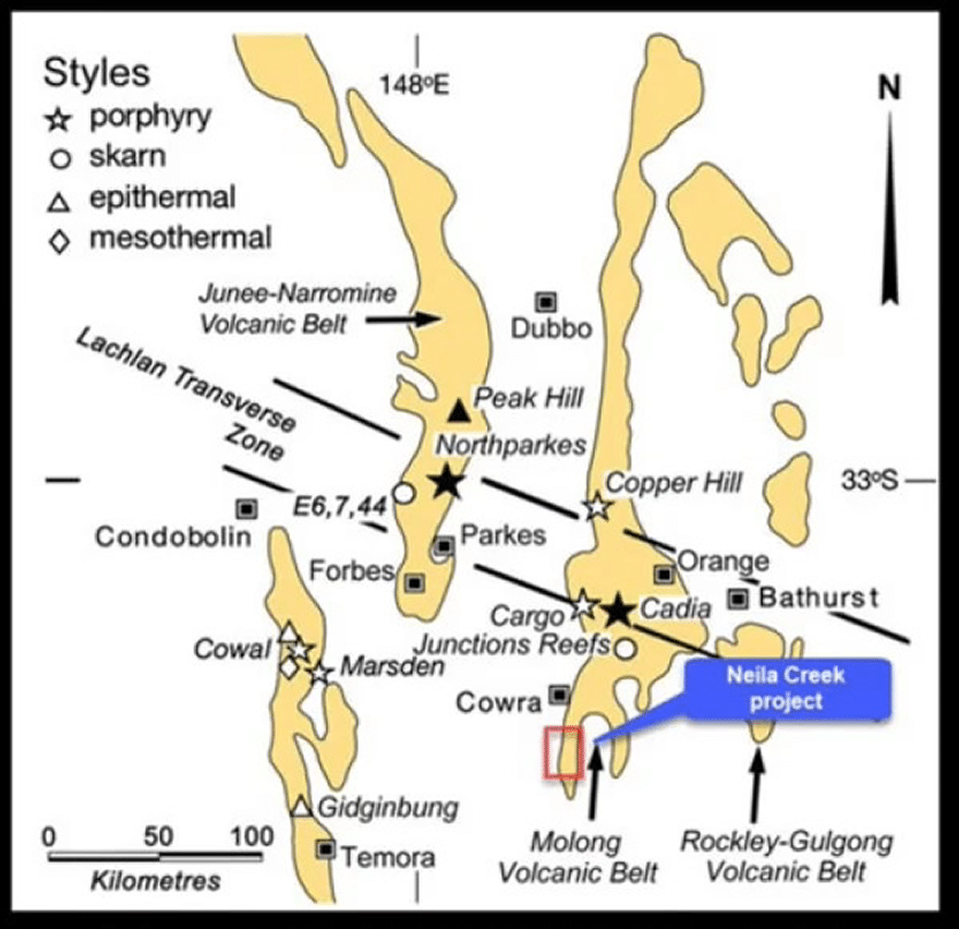
The tenement is unique in that it ranks highly in a specialised predictive modelling exercise established on results from an artificial neural network study completed by BWG Mining in 2006 across the entire Lachlan Fold Belt. This method is based on a weights of evidence logic and has clearly defined two targets (ranked as #6 and #42) on the tenement, one being a ‘bullseye’ target coincident with historic copper – gold workings as discussed above, and which will form the basis of the exploration drilling program.
The Neila Creek prospect is located approximately 300km west of Sydney or 115km north of Canberra. The project area can be accessed 5km south of the township of Cowra, then by secondary sealed and gravel roads which connect the farms in the region. The main Lachlan Valley Way highway traverses the entire tenement.
The Cowra township has a population of just under 10,000 people as at the June 2017 census. The Cowra Shire economy is largely based on agriculture – beef and dairy cattle, sheep, grain and viticulture.
Regional Geology and Mineralisation
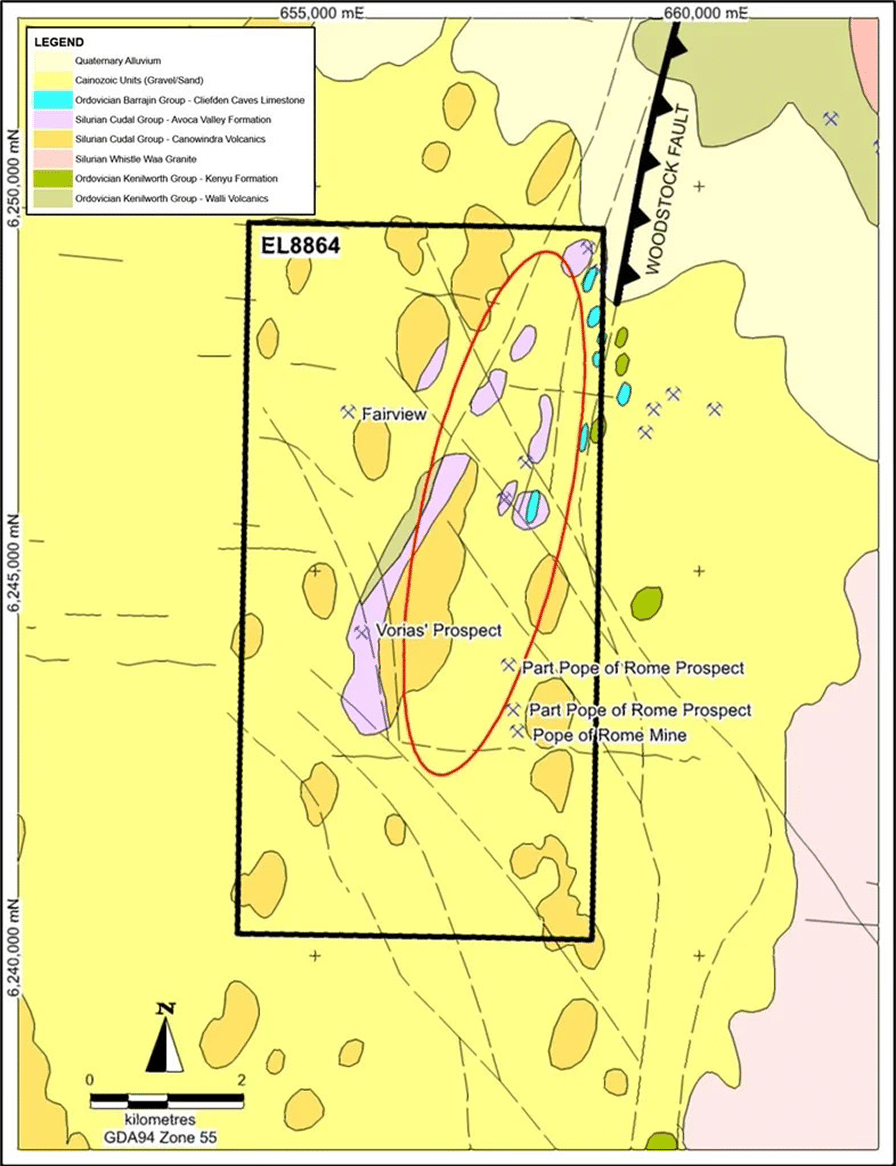
The tenement lies on the structurally complex western margin of the Ordovician Molong Volcanic Belt and the Silurian Cowra Trough. Volcanics and volcaniclastic sediments of the Silurian Cudal Group comprise the majority of the tenement area, with limited outcrop of Ordovician units.
The Ordovician basement rocks in the area are believed to be the Late Ordovician Kenyu Formation, which strike roughly north-south through the prospect area. This unit has tightly folded slaty cleavage and is metamorphosed to the lower greenschist facies. It is considered prospective for structurally controlled copper and gold mineralisation. Overlying the Kenyu Formation are the Canowindra Volcanics of the basal Cudal Group. These are the most widespread rocks across the tenement and are comprised of garnetiferous quartzo feldspathic rhyolite and rhyodacite lavas of high-K calc-alkaline affinity, together with tuff and coarse volcaniclastic sandstone.
These volcanics are comagmatic with the Cowra Granodiorite which intrudes them to the south of the tenement. Overlying the Canowindra Volcanics are shales, coarse garnetiferous sandstone and conglomerates of the Late Silurian Avoca Valley Formation.
Much of the basement units across the tenement are obscured by recent Cainozoic gravel and sand, resulting in gently undulating to level plains of 10 to 20m local relief to the north and south of the Lachlan River, which traverses east to west through the central zone of the tenement.
Local Geology & Mineralisation
Known mineral occurrences on the tenement are classified by the NSW Geological Survey (NSWGS) as being structurally controlled and are hosted predominantly within the Silurian Cudal Group units. It is the belief of the GGR geology team that these near surface manifestations are the consequence of ‘leakage’ veins emanating from deeper intrusive related gold – copper mineralisation systems. There are three main areas containing historical workings (as outlined below) which constitute the initial Area of Interest (AoI) for GGR, as well as a number of other un-named abandoned workings across the northern half of the title.
- The Pope of Rome Mine workings are located 2.5km east of Morongla Creek township and extend over a north-south oriented 1km strike length. The main workings are historically characterised by gossans at surface, trenches, shafts with drives, and stoping, over an area 80m in diameter. Pits occur along the strike length of the prospect. About 10 tons of copper ore were produced between 1900 and 1905, with primary sulphides of chalcopyrite and pyrite with secondary malachite. The mineralisation is found within quartz veins and felsic volcanic wall rocks surrounded by chlorite-carbonate-sericite-epidote alteration.
- Voria’s Prospect is located 1km east of Morongla Creek township in the central portion of the title. It consists of two shallow pits approximately 200m apart on quartz veins with Fe/Mn oxides after sulphide (?pyrite). The host rocks are altered andesitic tuff and calc-silicate rock, which have been mapped by the NSW Geological Survey as Avoca Valley Formation, however Hine (1990) assigns these rocks to the Ordovician Kenyu Formation. Anomalous Au (max 2.49g/t) was returned from rock chips in vein quartz.
- The Fairview Mine sits 5km north of the township of Morongla Creek in the northern portion of the title. Gold ore was produced from the mine in the mid-1930s. The gold, as gold and pyrite, is hosted in quartz veins which dip steeply to the north. The mine was recorded as having consisted of shafts, drives and stopes, however only a mullock-filled shaft remains alongside a >35m long trench (<1m deep) immediately east of the shaft.
Exploration Model – Target Generation
Given the focus provided by the known, historic copper and gold showings being coincident with the clearly defined BWG Neural Network target, along with the benefit of decades of previous exploration work, a conceptual first-pass geological model has been constructed indicating that immediate targets can be defined and tested with a program of moderately deep diamond drilling. This would allow for structural, alteration and mineralisation vectoring to be undertaken across a projected single cross section which would then be subjected to detailed multi-data processing of all historic and ‘new’ data providing the best possible information to advance further exploration.
The Company therefore aims to fast track the testing of Neila Creek by drilling three diamond core holes. Large porphyry copper gold deposits tend to have a significant footprint that is detectable by specific, diagnostic logging of drill core and characteristic geochemical analyses.
The proposed initial exploration at Neila Creek is planned to begin early in the 2025 reporting period and will consist of three diamond core holes (#1 to #3 in figure below) to approximately 400m depth for 1,200m total. A budget of approximately $400,000 is allocated for the first phase of exploration drilling. Depending on results, further work including follow-up drilling, geophysics and geochemical sampling will be considered for areas both within the initial AoI, and to the north in yet to be investigated areas.